

Design, Evaluation & Communications of Urban Real Estate
Plan.City is a set of site evaluation & presentation tools for the Architects and Urban Planners. Starting in London, Plan.City library now includes Dublin and Birmingham models with Cardiff and Bristol next in line. Customers are able to manipulate cities with new sets of tools and even optimise and import any existing or a 3rd party city model. Easy to pair with 3rd party databases, custom databases and 3rd party 3D models.
Plan.City 1.3 – Available for London | Birmingham | Dublin


Tools for Planners & AEC Industry
Powered by Unreal Engine 4, Plan.City is a unique city design & planning app by AccuCities. Architects, Developers and Urban Planners can rapidly evaluate development site, visualise and evaluate proposed designs and check these against a variety of planning restrictions. Design to work with large 3D city models datasets. Quick creation of state-of-the-art presentations and animations.

Plan.City is powered by UE4, the most advanced 3D game engine with built-in optimisation system. The app has been designed to be stable and work smoothly with large city models. Running on average gaming computer, the app was built and tested on 60 km sq AccuCities High Detail 3D London model with additional 120 sq km of 3D background model built from EA data.

Using keyboard and mouse or a game pad, users have complete control of movement within the digital twin environment. Fly or walk anywhere in the 3D model, explore all angles, experience the design from street level or from neighbouring properties. Switch to 3rd person view for better understanding of scale and context.

Graphics, Lighting and Environment Controls – Set Date, Time of Day and Weather conditions
Users can change number of graphics and performance settings to match their hardware. Geo-located city model of London simulates accurate sun and shadows. Time and Date settings can be used to simply alter the aesthetics or to examine proposed designs from daylight and sunlight perspective. Coming soon: Weather controls.

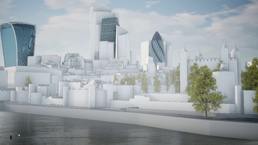
Future Skyline Layer Overlays – 3D models of major consented developments
Real estate developments proposed for a dense and busy city centres take years to complete. Plan.City: London has major future developments included and users can display these based on their estimated completion dates. This allows our customers to see the future and plan and design developments better.
Manipulate Existing 3D City Model – Built-in Tools to Remove & Create Buildings
Plan.City 1.1 allows users to clear site by hiding existing buildings and structures. Builder Tool allows easy envelope design of a new proposed structure in 3D. Watch more on YouTube (1:36). Object manipulation possible on multiple layers. Objects created using the Builder Tool can be exported in FBX format.

Import your 3D models into Plan.City – Evaluate Design Proposal in wide area city context
Import your proposed developments in FBX format into Plan City with few clicks. Visualise, evaluate and compare ideas and design in the context of its neighbourhood, wider area, local authority or entire city. Create & share impressive visuals, make 3D presentations in real time.

Overlay Public and Private Databases – Works with static and dynamic I/O Databases
Overlaying a 3D city model with existing city databases can help clients to better evaluate a development opportunity. From simple checks of area connectivity or number and type of developments in its vicinity, Plan.City users can overlay static, dynamic, I/O databases or even multimedia with city model.

To reflect regional variations, history and its envisioned future, many cities – London included – create a set of additional local planning laws and restrictions. Plan City includes London View Management Framework corridors, Protected Views and St. Pauls Cathedral Maximum Buildings Height grid. To comply with these bylaws, planners can quickly check designs against these restrictions. Watch on YouTube (1:36).

Urban Development & City Planning Tools – Rapid envelope design & evaluation
Planning a New Building or extending existing building? Use the Builder Tool to create 3D objects anywhere in the 3D city model. Check its height against ground, neighbouring properties or even distant landmarks. Measure existing environment with 15 cm accuracy. Create accurate maps of areas of potential visibility of your proposed developments and many, many more tools to design better urban spaces.

Communication & Presentations Tools – Quick creation of Hi-res Renders and Presentations
It is now easier to communicate design ideas with all the various stakeholders. Plan.City users can capture High Resolution renders in real time. Quickly create multi-view 3D presentations using wide area context model of the city. Use screen capture software to create impressive animations. For state-of-the-art presentations, Plan.City Pro users will be able to render 3D stereoscopic or 360 videos or even use the app with Virtual Reality headsets.
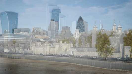

PhotoMatch Overlays – 3D Model / Camera matched images
High Detail London 3D City model can be overlayed with photos to combine 3D models of correct size, orientation and perspective with real photo of the area.
One – Plan.City Standard is designed for clients requiring the app for a specific site.
Two – Plan.City Pro includes fully editable app & 60 km sq London CAD data in Tiles.
To find out more click this LINK.
Andrew Stanton CEO Proptech-PR

Andrew Stanton Founder & Editor of 'PROPTECH-X' where his insights, connections, analysis and commentary on proptech and real estate are based on writing 1.3M words annually. Plus meeting 1,000 Proptech founders, critiquing 400 decks and having had 130 clients as CEO of 'PROPTECH-PR', a consultancy for Proptech founders seeking growth and exit strategies. He also acts as an advisory for major global real estate companies on sales, acquisitions, market positioning & operations. With 200K followers & readers, he is the 'Proptech Realestate Influencer.'
- Andrew Stantonhttps://proptech-x.com/author/andrew-stanton/

- Andrew Stantonhttps://proptech-x.com/author/andrew-stanton/
- Andrew Stantonhttps://proptech-x.com/author/andrew-stanton/
- Andrew Stantonhttps://proptech-x.com/author/andrew-stanton/